Water Tower Hill from the south with distant views of Prospect Lookout and Greystanes Hill beyond the new sheds of the industrial development.
The Walk: Three alternative ascents, two of them on on peaceful, well-surfaced roads at easy gradients, Route C up steep grass.
Distance: Route A 850 m; Route B 850 m; Route C 250 m; Circular Walk 2.75 km
Time: Routes A and B: 20 minutes ascent, 15 minutes descent; Circular Walk 50 minutes.
Getting there: Hillsbus 700 to Prospect Highway-Blacktown Road; walk along Prospect Highway across Gt Western Highway and M4. At next roundabout turn right into Reservoir Road and then 2nd left into Prospect Reservoir precinct; walk starts are at various points along William Lawson Drive. By car access the Prospect Reservoir precinct along the main access road (now named William Lawson Drive) from Reservoir Road, Prospect. Car parking: Car parks at the start of each route are in the Prospect Reservoir grounds off Reservoir Road. Note the opening times on the Access page and check them on the notices at the gate at the start of William Lawson Drive and at car parks.
Please see our Access page for information about the closure of the whole Prospect Reservoir precinct preventing all access to Water Tower Hill.
Route A
|
|

This walk starts at the George Maunder Lookout - Lower Level, which is just off William Lawson Drive, on the left past the water treatment works. This is a car park and picnic site and there are public toilets here.
Take the road that goes uphill to the left of the toilet block, stepping over the low gate which prevents vehicle access. Follow the road as it curves to the right until you reach a T-junction at the Quarry Fence with the notice "George Maunder Lookout Upper Level."
|
|

Resuming the route of ascent (from the T-junction) follow the roadway alongside the Quarry Fence as it climbs gently uphill to the summit with its two water towers.
Route B
|
|

Start at the mini-roundabout on William Lawson Drive. (If parking at Andrew Campbell Reserve, the mini-roundabout is a short walk further along the Drive.) Take the side road which leads off William Lawson Drive at the rondabout. Step through the wire fence on your right and follow its other side to inspect the site of William Lawson's home, Veteran Hall. First you will see a cairn and plaque marking the general area of the site. The bricks of the cairn are from the original house. On the right is a wooden post and rail fence marking the original paddock of the house. A short way further on, a raised platform indicates the position and extent of the house. The concrete slab only indicates part of its extent, possibly the area where a later extension or verandah was added.
Step back into the lane and continue uphill. The road turns sharp right when it meets the Quarry Fence and from here you have good views on your left across to the eastern ridge of Prospect Hill. In a moment you will pass the covered reservoir on your right and then reach the summit with its two water towers.
Route C
|
|

Start at the car park on the left of William Lawson Drive just after the water treatment plant. Some of the water pipes used to transport water from Prospect to Sydney are on show here with information boards.
Walk along to the Maintenance Office and ascend the firebreak which rises steeply uphill towards the concrete water tower at the top. The last few yards are the steepest but the whole climb should not take more than about five minutes.
The Summit
|
|

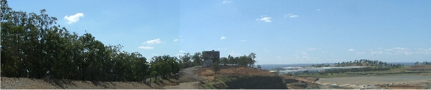
The top of Water Tower Hill is 116 metres above sea level. This is a metre below the height of Greystanes Hill, the highest point of Prospect Hill. The trig point marked 140 m on NSW Lands Dept. maps is on top of the older, concrete water tower which is known as Prospect Hill Elevated Reservoir. It was built in 1934 and is heritage listed. "The concrete reservoir has stepped or tapered sides. The doorways at the base and top of the tower have unusual 'Egyptian' style door frames." (1). The other, metal-clad water tower was built quite recently, probably since 2000. For more details see the Water Tower Hill page of the Description section.
The View from Water Tower Hill
|
|

The view westwards is partly obstructed by trees, but through the fire break Prospect Reservoir is seen below. Beyond it there is a slight rise and then the ground drops gently all the way to the River Nepean nearly 30 kilometres away. In the distance the Blue Mountains appear, normally as a featureless, hazy ridge-line. It is difficult to say how far you can see. The mountains start to rise from the River Nepean and continue rising up to Katoomba which is nearly 60 km away.
|
|

|
|

|
|

Descent routes
The descent by Route C down the grassy fire break towards Prospect Reservoir is especially steep near the top, so don't go down this way unless you are confident of getting down safely.
Routes A and B are easy descent routes and either can be combined with the other to provide a circular walk of about fifty minutes. The walk between the starting points of Routes A and B is a straightforward 15 minute walk along William Lawson Drive.
(1) "Prospect Hill Reservoir (Elevated) (WS 95) was completed in 1934. The original reservoir was built in 1915 and removed in 1936. Another concrete reservoir was built below WS 95 in 1937." The NSW State Agency Heritage Register is a list of items listed by Local Government and State agencies. (Heritage, Prospect Hill Reservoir (Elevated)). (« Back)