|
|
(See also the Water Tower Hill walk page.)
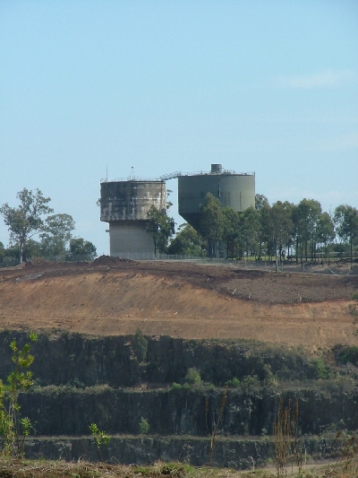
This summit is the second highest point of Prospect Hill, being a metre less than Greystanes Hill. It is crowned by two large water towers, which dominate its appearance from easterly directions. However the hill is well wooded with mostly native trees and these partially shield the water-towers from westerly views. Next to the towers is a covered reservoir known as Prospect Hill Reservoir built in 1938 - not to be confused with the very much larger Prospect Reservoir to the west. Prospect Elevated (presumably the more modern of the two towers) was completed in 1957. Both are supplied by pumping water from the main Prospect Reservoir. The older of the two towers was built in 1934 and is listed on the NSW State agency heritage register (Heritage, Prospect Hill Reservoir (Elevated) (WS 95)).
To start with I thought that this was the highest point of Prospect Hill since the NSW Lands map shows a triangulation point labelled as Prospect Hill, 140 metres above sea level, at the summit of this hill. However there is no sign of a trig point on the ground. Eventually I noticed it at the top of one of the towers, which means the summit at ground level is much less than 140 metres high. Contour maps support this view (1).
I have found evidence that Water Tower Hill is 116 metres high at the ground level of its summit, while Greystanes Hill, the highest point of the eastern section of Prospect Hill, is reported to be 117 metres above sea level (2).
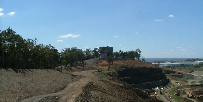
A sealed access road reaches the summit from the north-north-east. It starts from the Prospect Reservoir Access Road near the site of Veterans Hall, passes across the northern slopes of the summit, and then turns sharp right when it reaches the quarry fence which it follows to the summit. The road continues past the covered reservoir and water towers at the summit to join with the roadway of the now closed and derelict Upper Maunder Picnic Area.
The boundary fence of the quarry runs alongside this road from the sharp turn all the way to the southern end of the Upper Lookout picnic area. It thus passes close under the water towers and within say 30 metres of the summit. The land drops steeply to the east of the fence along its entire length, apart from a level bench occupied by a quarry access road. Below this the ground drops steeply to the vertical rock face of the quarry's western side.
Water Tower Hill from the South in 2008
The western and northern slopes of the Water Tower Hill are covered with dense woodland. They are very steep in places and so pretty well impenetrable. A fire break descends straight down from the summit to the water treatment works on the shore of Prospect Reservoir.
Water Tower Hill from the North. The water tower is barely visible slightly left of centre.
(1) The 1955 map (Liverpool map) shows a height of 453 [feet] labelled "(Top Tower)" at Water Tower Hill. This is equivalent to 138 metres. No trig point symbol appears. Significantly there is no 400 ft contour around the summit, the highest being 350 ft. This implies that this summit is between 107 and 122 metres in height at ground level. («)
(2) A map "after Wilshire 1967" based on topography by Cumberland Co Council 1964 gives the height as 380 ft which converts to 116 metres. This seems the most likely height of Water Tower Hill at ground level. "Marrong Reserve ... contains the highest point [my Greystanes Hill] within the study area, rising 117m above sea level." (Holroyd 2008, p 31). («)